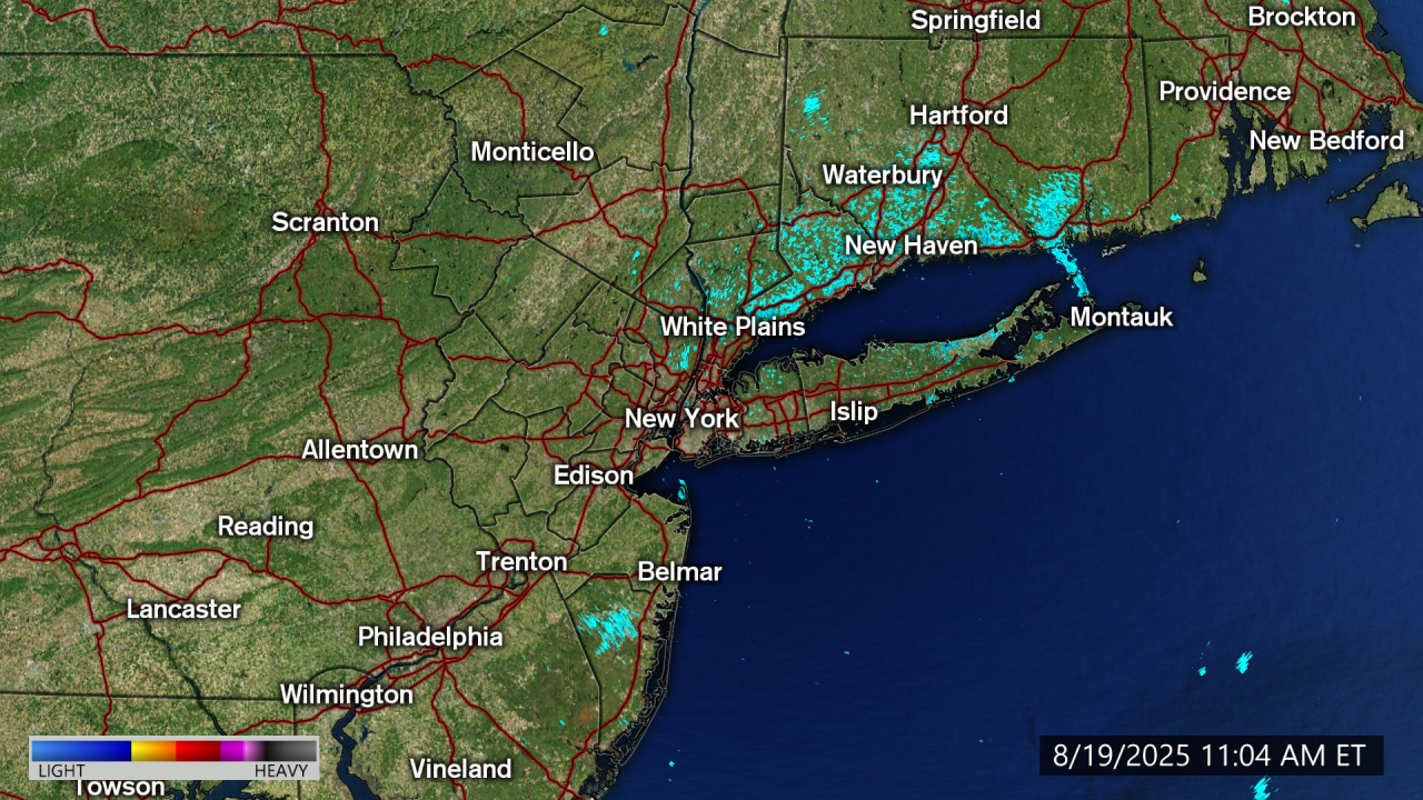
AccuTrack Radar
- Coastal Flood Advisory
* WHAT...For the High Rip Current Risk, life-threatening rip currents. For the High Surf Advisory, breaking waves building to 9 to 13 feet through tonight, subsiding to 5 to 9 feet by Friday afternoon. For the Coastal Flood Warning, 2 to 2 1/2 feet of inundation above ground level expected in vulnerable areas near the waterfront and shoreline. For the first and second Coastal Flood Advisories, up to 1 1/2 ft of inundation above ground level expected. * WHERE...Southern Queens County. * WHEN...For the High Surf Advisory, until 8 PM EDT Friday. For the High Rip Current Risk, through Friday evening. For the Coastal Flood Warning, from 5 PM today to 1 AM EDT Friday. For the first Coastal Flood Advisory, from 5 AM to 1 PM EDT Friday. For the second Coastal Flood Advisory, from 6 PM Friday to 2 AM EDT Saturday. * COASTAL FLOOD IMPACTS...Widespread moderate flooding of vulnerable areas near the waterfront and shoreline with this evening's high tide. Expect 2 to 2 1/2 ft of inundation above ground level in low lying, vulnerable areas. This will result in numerous road closures and cause widespread flooding of low lying property including parking lots, parks, lawns and homes/businesses with basements near the waterfront. Vehicles parked in vulnerable areas near the waterfront will likely become flooded. * SWIMMING IMPACTS...Life-threatening swimming and surfing conditions and localized beach erosion. Life-threatening rip currents are likely for all people entering the surf zone. Anyone visiting the beaches should stay out of the surf. Rip currents can sweep even the best swimmers away from shore into deeper water. * SHORELINE IMPACTS...The threat for beach flooding and beach erosion will increase with successive high tides thru Fri morning. Scattered areas of dune erosion are likely during the Thu eve and Fri morning high tides.More
- Coastal Flood Advisory
* WHAT...For the first Coastal Flood Advisory, 1 to 2 ft of inundation above ground level expected in vulnerable areas near the waterfront and shoreline. For the second Coastal Flood Advisory, 1 to 1 1/2 ft of inundation above ground level expected in vulnerable areas near the waterfront and shoreline. * WHERE...In Connecticut, Southern Fairfield County. In New York, Southern Westchester County. * WHEN...For the first Coastal Flood Advisory, from 8 PM today to 1 AM EDT Friday. For the second Coastal Flood Advisory, from 10 PM Friday to 2 AM EDT Saturday. * COASTAL FLOOD IMPACTS...Minor flooding is expected in the most vulnerable locations near the waterfront and shoreline. Expect 1 to 2 feet of inundation above ground level in low lying, vulnerable areas. Some roads and low lying property including parking lots, parks, lawns and homes/businesses with basements near the waterfront will experience shallow flooding.More
- Coastal Flood Advisory
* WHAT...For the High Rip Current Risk, life-threatening rip currents. For the High Surf Advisory, large breaking waves building to 12 to 16 ft through tonight, subsiding to and 8 to 12 feet on Friday afternoon. For the Coastal Flood Warning, 2 to 2 1/2 feet of inundation above ground level expected in vulnerable areas near the waterfront and shoreline. For the first and second Coastal Flood Advisories, 1 to 2 ft of inundation above ground level likely. * WHERE...Southwest Suffolk and Southern Nassau Counties. * WHEN...For the High Surf Advisory, until 8 PM EDT Friday. For the High Rip Current Risk, through Friday evening. For the Coastal Flood Warning, from 5 PM today to 1 AM EDT Friday. For the first Coastal Flood Advisory, from 5 AM to 1 PM EDT Friday. For the second Coastal Flood Advisory, from 6 PM Friday to 2 AM EDT Saturday. * COASTAL FLOOD IMPACTS...Widespread moderate flooding of vulnerable areas near the waterfront and shoreline with this evening's high tide. Expect 2 to 2 1/2 ft of inundation above ground level in low lying, vulnerable areas. This will result in numerous road closures and cause widespread flooding of low lying property including parking lots, parks, lawns and homes/businesses with basements near the waterfront. Vehicles parked in vulnerable areas near the waterfront will likely become flooded. * SWIMMING IMPACTS...Life-threatening swimming and surfing conditions and localized beach erosion. Life-threatening rip currents are likely for all people entering the surf zone. Anyone visiting the beaches should stay out of the surf. Rip currents can sweep even the best swimmers away from shore into deeper water. * SHORELINE IMPACTS...The threat for dune erosion and beach flooding will increase with successive high tides thru Fri morning. Widespread areas of dune erosion with localized overwashes are expected during the Thu evening and Fri morning high tides.More
- Coastal Flood Advisory
* WHAT...For the High Rip Current Risk, life-threatening rip currents. For the High Surf Advisory, breaking waves building to 9 to 13 feet through tonight, subsiding to 5 to 9 feet by Friday afternoon. For the Coastal Flood Warning, 2 to 2 1/2 feet of inundation above ground level expected in vulnerable areas near the waterfront and shoreline. For the first and second Coastal Flood Advisories, up to 1 1/2 ft of inundation above ground level expected. * WHERE...Southern Queens County. * WHEN...For the High Surf Advisory, until 8 PM EDT Friday. For the High Rip Current Risk, through Friday evening. For the Coastal Flood Warning, from 5 PM today to 1 AM EDT Friday. For the first Coastal Flood Advisory, from 5 AM to 1 PM EDT Friday. For the second Coastal Flood Advisory, from 6 PM Friday to 2 AM EDT Saturday. * COASTAL FLOOD IMPACTS...Widespread moderate flooding of vulnerable areas near the waterfront and shoreline with this evening's high tide. Expect 2 to 2 1/2 ft of inundation above ground level in low lying, vulnerable areas. This will result in numerous road closures and cause widespread flooding of low lying property including parking lots, parks, lawns and homes/businesses with basements near the waterfront. Vehicles parked in vulnerable areas near the waterfront will likely become flooded. * SWIMMING IMPACTS...Life-threatening swimming and surfing conditions and localized beach erosion. Life-threatening rip currents are likely for all people entering the surf zone. Anyone visiting the beaches should stay out of the surf. Rip currents can sweep even the best swimmers away from shore into deeper water. * SHORELINE IMPACTS...The threat for beach flooding and beach erosion will increase with successive high tides thru Fri morning. Scattered areas of dune erosion are likely during the Thu eve and Fri morning high tides.More
- Coastal Flood Advisory
* WHAT...For the High Rip Current Risk, life-threatening rip currents. For the High Surf Advisory, breaking waves building to 8 to 12 feet through tonight, subsiding to 4 to 8 feet by Friday afternoon. For the Coastal Flood Advisories, 1 to 2 ft of inundation above ground level expected. * WHERE...Kings (Brooklyn) County. * WHEN...For the High Surf Advisory, until 8 PM EDT Friday. For the High Rip Current Risk, through Friday evening. For the first Coastal Flood Advisory, from 6 PM to 11 PM EDT today. For the second Coastal Flood Advisory, from 6 PM to 11 PM EDT Friday. * COASTAL FLOOD IMPACTS...Minor flooding is expected in the most vulnerable locations near the waterfront and shoreline. Expect 1 to 2 feet of inundation above ground level in low lying, vulnerable areas. Some roads and low lying property including parking lots, parks, lawns and homes/businesses with basements near the waterfront will experience shallow flooding. * SWIMMING IMPACTS...Life-threatening swimming and surfing conditions and localized beach erosion. Life-threatening rip currents are likely for all people entering the surf zone. Anyone visiting the beaches should stay out of the surf. Rip currents can sweep even the best swimmers away from shore into deeper water. * SHORELINE IMPACTS...The threat for beach erosion and beach flooding will increase with successive high tides thru Fri morning. Scattered areas of dune erosion are possible during the Thu eve and Fri morning high tides.More
- Coastal Flood Advisory
* WHAT...For the Coastal Flood Advisories, 1 to 2 ft of inundation above ground level expected. * WHERE...In New Jersey, Hudson, Eastern Essex and Eastern Union Counties. In New York, New York (Manhattan) County. * WHEN...For the first Coastal Flood Advisory, from 6 PM to 11 PM EDT today. For the second Coastal Flood Advisory, from 6 PM to 11 PM EDT Friday. * COASTAL FLOOD IMPACTS...Minor flooding is expected in the most vulnerable locations near the waterfront and shoreline. Expect 1 to 2 feet of inundation above ground level in low lying, vulnerable areas. Some roads and low lying property including parking lots, parks, lawns and homes/businesses with basements near the waterfront will experience shallow flooding.More
- Rip Current Statement
* WHAT...For the High Rip Current Risk, life-threatening rip currents. For the High Surf Advisory, large breaking waves building to 12 to 16 ft through tonight, subsiding to and 8 to 12 feet on Friday afternoon. For the Coastal Flood Warning, 1 1/2 to 2 feet of inundation above ground level expected in vulnerable areas near the waterfront and shoreline. For the Coastal Flood Advisory, up to 1 1/2 ft of inundation above ground level likely. Moderate coastal flooding potential will be highest for north facing shoreline areas along the southern and eastern bays, due to to enhanced wave action. This includes Orient Point. * WHERE...Southeast Suffolk County. * WHEN...For the High Surf Advisory, until 8 PM EDT Friday. For the High Rip Current Risk, through Friday evening. For the Coastal Flood Warning, from 5 PM today to 3 AM EDT Friday. For the Coastal Flood Advisory, from 5 AM to 2 PM EDT Friday. * COASTAL FLOOD IMPACTS...Widespread minor to locally moderate flooding of vulnerable areas near the waterfront and shoreline with this evening's high tide. Expect 1 1/2 to 2 ft of inundation above ground level in low lying, vulnerable areas. This will result in numerous road closures and cause widespread flooding of low lying property including parking lots, parks, lawns and homes/businesses with basements near the waterfront. Vehicles parked in vulnerable areas near the waterfront will likely become flooded. * SWIMMING IMPACTS...Life-threatening swimming and surfing conditions and localized beach erosion. Life-threatening rip currents are likely for all people entering the surf zone. Anyone visiting the beaches should stay out of the surf. Rip currents can sweep even the best swimmers away from shore into deeper water. * SHORELINE IMPACTS...Along the ocean front, the threat for dune erosion and beach flooding will increase with successive high tides thru Fri morning. Widespread areas of dune erosion with localized overwashes are expected during the Thu evening and Fri morning high tides along the ocean front. Along the north shore of the south fork, 2 to 4 ft breaking waves will result in beach erosion and locally moderate flooding of shoreline roads and properties during this evening's high tide. Along the north facing shore of the barrier islands, 1 to 3 ft breaking waves will result in beach erosion and locally moderate flooding flooding of shoreline roads and properties during this evening's high tideMore
- Rip Current Statement
* WHAT...For the High Rip Current Risk, life-threatening rip currents. For the High Surf Advisory, large breaking waves building to 12 to 16 ft through tonight, subsiding to and 8 to 12 feet on Friday afternoon. For the Coastal Flood Warning, 2 to 2 1/2 feet of inundation above ground level expected in vulnerable areas near the waterfront and shoreline. For the first and second Coastal Flood Advisories, 1 to 2 ft of inundation above ground level likely. * WHERE...Southwest Suffolk and Southern Nassau Counties. * WHEN...For the High Surf Advisory, until 8 PM EDT Friday. For the High Rip Current Risk, through Friday evening. For the Coastal Flood Warning, from 5 PM today to 1 AM EDT Friday. For the first Coastal Flood Advisory, from 5 AM to 1 PM EDT Friday. For the second Coastal Flood Advisory, from 6 PM Friday to 2 AM EDT Saturday. * COASTAL FLOOD IMPACTS...Widespread moderate flooding of vulnerable areas near the waterfront and shoreline with this evening's high tide. Expect 2 to 2 1/2 ft of inundation above ground level in low lying, vulnerable areas. This will result in numerous road closures and cause widespread flooding of low lying property including parking lots, parks, lawns and homes/businesses with basements near the waterfront. Vehicles parked in vulnerable areas near the waterfront will likely become flooded. * SWIMMING IMPACTS...Life-threatening swimming and surfing conditions and localized beach erosion. Life-threatening rip currents are likely for all people entering the surf zone. Anyone visiting the beaches should stay out of the surf. Rip currents can sweep even the best swimmers away from shore into deeper water. * SHORELINE IMPACTS...The threat for dune erosion and beach flooding will increase with successive high tides thru Fri morning. Widespread areas of dune erosion with localized overwashes are expected during the Thu evening and Fri morning high tides.More
- Rip Current Statement
* WHAT...For the High Rip Current Risk, life-threatening rip currents. For the High Surf Advisory, breaking waves building to 8 to 12 feet through tonight, subsiding to 4 to 8 feet by Friday afternoon. For the Coastal Flood Advisories, 1 to 2 ft of inundation above ground level expected. * WHERE...Kings (Brooklyn) County. * WHEN...For the High Surf Advisory, until 8 PM EDT Friday. For the High Rip Current Risk, through Friday evening. For the first Coastal Flood Advisory, from 6 PM to 11 PM EDT today. For the second Coastal Flood Advisory, from 6 PM to 11 PM EDT Friday. * COASTAL FLOOD IMPACTS...Minor flooding is expected in the most vulnerable locations near the waterfront and shoreline. Expect 1 to 2 feet of inundation above ground level in low lying, vulnerable areas. Some roads and low lying property including parking lots, parks, lawns and homes/businesses with basements near the waterfront will experience shallow flooding. * SWIMMING IMPACTS...Life-threatening swimming and surfing conditions and localized beach erosion. Life-threatening rip currents are likely for all people entering the surf zone. Anyone visiting the beaches should stay out of the surf. Rip currents can sweep even the best swimmers away from shore into deeper water. * SHORELINE IMPACTS...The threat for beach erosion and beach flooding will increase with successive high tides thru Fri morning. Scattered areas of dune erosion are possible during the Thu eve and Fri morning high tides.More
- High Surf Advisory
* WHAT...For the High Rip Current Risk, life-threatening rip currents. For the High Surf Advisory, large breaking waves building to 12 to 16 ft through tonight, subsiding to and 8 to 12 feet on Friday afternoon. For the Coastal Flood Warning, 1 1/2 to 2 feet of inundation above ground level expected in vulnerable areas near the waterfront and shoreline. For the Coastal Flood Advisory, up to 1 1/2 ft of inundation above ground level likely. Moderate coastal flooding potential will be highest for north facing shoreline areas along the southern and eastern bays, due to to enhanced wave action. This includes Orient Point. * WHERE...Southeast Suffolk County. * WHEN...For the High Surf Advisory, until 8 PM EDT Friday. For the High Rip Current Risk, through Friday evening. For the Coastal Flood Warning, from 5 PM today to 3 AM EDT Friday. For the Coastal Flood Advisory, from 5 AM to 2 PM EDT Friday. * COASTAL FLOOD IMPACTS...Widespread minor to locally moderate flooding of vulnerable areas near the waterfront and shoreline with this evening's high tide. Expect 1 1/2 to 2 ft of inundation above ground level in low lying, vulnerable areas. This will result in numerous road closures and cause widespread flooding of low lying property including parking lots, parks, lawns and homes/businesses with basements near the waterfront. Vehicles parked in vulnerable areas near the waterfront will likely become flooded. * SWIMMING IMPACTS...Life-threatening swimming and surfing conditions and localized beach erosion. Life-threatening rip currents are likely for all people entering the surf zone. Anyone visiting the beaches should stay out of the surf. Rip currents can sweep even the best swimmers away from shore into deeper water. * SHORELINE IMPACTS...Along the ocean front, the threat for dune erosion and beach flooding will increase with successive high tides thru Fri morning. Widespread areas of dune erosion with localized overwashes are expected during the Thu evening and Fri morning high tides along the ocean front. Along the north shore of the south fork, 2 to 4 ft breaking waves will result in beach erosion and locally moderate flooding of shoreline roads and properties during this evening's high tide. Along the north facing shore of the barrier islands, 1 to 3 ft breaking waves will result in beach erosion and locally moderate flooding flooding of shoreline roads and properties during this evening's high tideMore
- High Surf Advisory
* WHAT...For the High Rip Current Risk, life-threatening rip currents. For the High Surf Advisory, breaking waves building to 8 to 12 feet through tonight, subsiding to 4 to 8 feet by Friday afternoon. For the Coastal Flood Advisories, 1 to 2 ft of inundation above ground level expected. * WHERE...Kings (Brooklyn) County. * WHEN...For the High Surf Advisory, until 8 PM EDT Friday. For the High Rip Current Risk, through Friday evening. For the first Coastal Flood Advisory, from 6 PM to 11 PM EDT today. For the second Coastal Flood Advisory, from 6 PM to 11 PM EDT Friday. * COASTAL FLOOD IMPACTS...Minor flooding is expected in the most vulnerable locations near the waterfront and shoreline. Expect 1 to 2 feet of inundation above ground level in low lying, vulnerable areas. Some roads and low lying property including parking lots, parks, lawns and homes/businesses with basements near the waterfront will experience shallow flooding. * SWIMMING IMPACTS...Life-threatening swimming and surfing conditions and localized beach erosion. Life-threatening rip currents are likely for all people entering the surf zone. Anyone visiting the beaches should stay out of the surf. Rip currents can sweep even the best swimmers away from shore into deeper water. * SHORELINE IMPACTS...The threat for beach erosion and beach flooding will increase with successive high tides thru Fri morning. Scattered areas of dune erosion are possible during the Thu eve and Fri morning high tides.More
- High Surf Advisory
* WHAT...For the High Rip Current Risk, life-threatening rip currents. For the High Surf Advisory, large breaking waves building to 12 to 16 ft through tonight, subsiding to and 8 to 12 feet on Friday afternoon. For the Coastal Flood Warning, 2 to 2 1/2 feet of inundation above ground level expected in vulnerable areas near the waterfront and shoreline. For the first and second Coastal Flood Advisories, 1 to 2 ft of inundation above ground level likely. * WHERE...Southwest Suffolk and Southern Nassau Counties. * WHEN...For the High Surf Advisory, until 8 PM EDT Friday. For the High Rip Current Risk, through Friday evening. For the Coastal Flood Warning, from 5 PM today to 1 AM EDT Friday. For the first Coastal Flood Advisory, from 5 AM to 1 PM EDT Friday. For the second Coastal Flood Advisory, from 6 PM Friday to 2 AM EDT Saturday. * COASTAL FLOOD IMPACTS...Widespread moderate flooding of vulnerable areas near the waterfront and shoreline with this evening's high tide. Expect 2 to 2 1/2 ft of inundation above ground level in low lying, vulnerable areas. This will result in numerous road closures and cause widespread flooding of low lying property including parking lots, parks, lawns and homes/businesses with basements near the waterfront. Vehicles parked in vulnerable areas near the waterfront will likely become flooded. * SWIMMING IMPACTS...Life-threatening swimming and surfing conditions and localized beach erosion. Life-threatening rip currents are likely for all people entering the surf zone. Anyone visiting the beaches should stay out of the surf. Rip currents can sweep even the best swimmers away from shore into deeper water. * SHORELINE IMPACTS...The threat for dune erosion and beach flooding will increase with successive high tides thru Fri morning. Widespread areas of dune erosion with localized overwashes are expected during the Thu evening and Fri morning high tides.More
- High Surf Advisory
* WHAT...For the High Rip Current Risk, life-threatening rip currents. For the High Surf Advisory, breaking waves building to 9 to 13 feet through tonight, subsiding to 5 to 9 feet by Friday afternoon. For the Coastal Flood Warning, 2 to 2 1/2 feet of inundation above ground level expected in vulnerable areas near the waterfront and shoreline. For the first and second Coastal Flood Advisories, up to 1 1/2 ft of inundation above ground level expected. * WHERE...Southern Queens County. * WHEN...For the High Surf Advisory, until 8 PM EDT Friday. For the High Rip Current Risk, through Friday evening. For the Coastal Flood Warning, from 5 PM today to 1 AM EDT Friday. For the first Coastal Flood Advisory, from 5 AM to 1 PM EDT Friday. For the second Coastal Flood Advisory, from 6 PM Friday to 2 AM EDT Saturday. * COASTAL FLOOD IMPACTS...Widespread moderate flooding of vulnerable areas near the waterfront and shoreline with this evening's high tide. Expect 2 to 2 1/2 ft of inundation above ground level in low lying, vulnerable areas. This will result in numerous road closures and cause widespread flooding of low lying property including parking lots, parks, lawns and homes/businesses with basements near the waterfront. Vehicles parked in vulnerable areas near the waterfront will likely become flooded. * SWIMMING IMPACTS...Life-threatening swimming and surfing conditions and localized beach erosion. Life-threatening rip currents are likely for all people entering the surf zone. Anyone visiting the beaches should stay out of the surf. Rip currents can sweep even the best swimmers away from shore into deeper water. * SHORELINE IMPACTS...The threat for beach flooding and beach erosion will increase with successive high tides thru Fri morning. Scattered areas of dune erosion are likely during the Thu eve and Fri morning high tides.More
- Rip Current Statement
* WHAT...For the High Rip Current Risk, life-threatening rip currents. For the High Surf Advisory, breaking waves building to 9 to 13 feet through tonight, subsiding to 5 to 9 feet by Friday afternoon. For the Coastal Flood Warning, 2 to 2 1/2 feet of inundation above ground level expected in vulnerable areas near the waterfront and shoreline. For the first and second Coastal Flood Advisories, up to 1 1/2 ft of inundation above ground level expected. * WHERE...Southern Queens County. * WHEN...For the High Surf Advisory, until 8 PM EDT Friday. For the High Rip Current Risk, through Friday evening. For the Coastal Flood Warning, from 5 PM today to 1 AM EDT Friday. For the first Coastal Flood Advisory, from 5 AM to 1 PM EDT Friday. For the second Coastal Flood Advisory, from 6 PM Friday to 2 AM EDT Saturday. * COASTAL FLOOD IMPACTS...Widespread moderate flooding of vulnerable areas near the waterfront and shoreline with this evening's high tide. Expect 2 to 2 1/2 ft of inundation above ground level in low lying, vulnerable areas. This will result in numerous road closures and cause widespread flooding of low lying property including parking lots, parks, lawns and homes/businesses with basements near the waterfront. Vehicles parked in vulnerable areas near the waterfront will likely become flooded. * SWIMMING IMPACTS...Life-threatening swimming and surfing conditions and localized beach erosion. Life-threatening rip currents are likely for all people entering the surf zone. Anyone visiting the beaches should stay out of the surf. Rip currents can sweep even the best swimmers away from shore into deeper water. * SHORELINE IMPACTS...The threat for beach flooding and beach erosion will increase with successive high tides thru Fri morning. Scattered areas of dune erosion are likely during the Thu eve and Fri morning high tides.More
- Coastal Flood Advisory
* WHAT...For the High Rip Current Risk, life-threatening rip currents. For the High Surf Advisory, large breaking waves building to 12 to 16 ft through tonight, subsiding to and 8 to 12 feet on Friday afternoon. For the Coastal Flood Warning, 1 1/2 to 2 feet of inundation above ground level expected in vulnerable areas near the waterfront and shoreline. For the Coastal Flood Advisory, up to 1 1/2 ft of inundation above ground level likely. Moderate coastal flooding potential will be highest for north facing shoreline areas along the southern and eastern bays, due to to enhanced wave action. This includes Orient Point. * WHERE...Southeast Suffolk County. * WHEN...For the High Surf Advisory, until 8 PM EDT Friday. For the High Rip Current Risk, through Friday evening. For the Coastal Flood Warning, from 5 PM today to 3 AM EDT Friday. For the Coastal Flood Advisory, from 5 AM to 2 PM EDT Friday. * COASTAL FLOOD IMPACTS...Widespread minor to locally moderate flooding of vulnerable areas near the waterfront and shoreline with this evening's high tide. Expect 1 1/2 to 2 ft of inundation above ground level in low lying, vulnerable areas. This will result in numerous road closures and cause widespread flooding of low lying property including parking lots, parks, lawns and homes/businesses with basements near the waterfront. Vehicles parked in vulnerable areas near the waterfront will likely become flooded. * SWIMMING IMPACTS...Life-threatening swimming and surfing conditions and localized beach erosion. Life-threatening rip currents are likely for all people entering the surf zone. Anyone visiting the beaches should stay out of the surf. Rip currents can sweep even the best swimmers away from shore into deeper water. * SHORELINE IMPACTS...Along the ocean front, the threat for dune erosion and beach flooding will increase with successive high tides thru Fri morning. Widespread areas of dune erosion with localized overwashes are expected during the Thu evening and Fri morning high tides along the ocean front. Along the north shore of the south fork, 2 to 4 ft breaking waves will result in beach erosion and locally moderate flooding of shoreline roads and properties during this evening's high tide. Along the north facing shore of the barrier islands, 1 to 3 ft breaking waves will result in beach erosion and locally moderate flooding flooding of shoreline roads and properties during this evening's high tideMore
- Coastal Flood Advisory
* WHAT...For the Coastal Flood Warning, up to 2 ft of inundation above ground level expected in vulnerable areas near the waterfront and shoreline. For the Coastal Flood Advisory, around 1 ft of inundation above ground level expected in vulnerable areas near the waterfront and shoreline. * WHERE...Northeast Suffolk County. * WHEN...For the Coastal Flood Warning, from 5 PM today to 3 AM EDT Friday. For the Coastal Flood Advisory, from 5 AM to 2 PM EDT Friday. * COASTAL FLOOD IMPACTS...Widespread minor to locally moderate flooding of vulnerable areas near the waterfront and shoreline with this evening's high tide. Expect 1 1/2 to 2 ft of inundation above ground level in low lying, vulnerable areas, particularly near Orient Point and the Peconic River. This will result in several road closures and cause flooding of low lying property including parking lots, parks, lawns and homes/businesses with basements near the waterfront. Vehicles parked in vulnerable areas near the waterfront will likely become flooded. * SHORELINE IMPACTS...Along Orient point, 3 to 5 ft breaking waves will result in beach erosion and locally moderate flooding of shoreline roads and properties during this evening's high tide.More
- Coastal Flood Advisory
* WHAT...For the High Rip Current Risk, life-threatening rip currents. For the High Surf Advisory, large breaking waves building to 12 to 16 ft through tonight, subsiding to and 8 to 12 feet on Friday afternoon. For the Coastal Flood Warning, 2 to 2 1/2 feet of inundation above ground level expected in vulnerable areas near the waterfront and shoreline. For the first and second Coastal Flood Advisories, 1 to 2 ft of inundation above ground level likely. * WHERE...Southwest Suffolk and Southern Nassau Counties. * WHEN...For the High Surf Advisory, until 8 PM EDT Friday. For the High Rip Current Risk, through Friday evening. For the Coastal Flood Warning, from 5 PM today to 1 AM EDT Friday. For the first Coastal Flood Advisory, from 5 AM to 1 PM EDT Friday. For the second Coastal Flood Advisory, from 6 PM Friday to 2 AM EDT Saturday. * COASTAL FLOOD IMPACTS...Widespread moderate flooding of vulnerable areas near the waterfront and shoreline with this evening's high tide. Expect 2 to 2 1/2 ft of inundation above ground level in low lying, vulnerable areas. This will result in numerous road closures and cause widespread flooding of low lying property including parking lots, parks, lawns and homes/businesses with basements near the waterfront. Vehicles parked in vulnerable areas near the waterfront will likely become flooded. * SWIMMING IMPACTS...Life-threatening swimming and surfing conditions and localized beach erosion. Life-threatening rip currents are likely for all people entering the surf zone. Anyone visiting the beaches should stay out of the surf. Rip currents can sweep even the best swimmers away from shore into deeper water. * SHORELINE IMPACTS...The threat for dune erosion and beach flooding will increase with successive high tides thru Fri morning. Widespread areas of dune erosion with localized overwashes are expected during the Thu evening and Fri morning high tides.More
- Coastal Flood Warning
* WHAT...For the High Rip Current Risk, life-threatening rip currents. For the High Surf Advisory, large breaking waves building to 12 to 16 ft through tonight, subsiding to and 8 to 12 feet on Friday afternoon. For the Coastal Flood Warning, 1 1/2 to 2 feet of inundation above ground level expected in vulnerable areas near the waterfront and shoreline. For the Coastal Flood Advisory, up to 1 1/2 ft of inundation above ground level likely. Moderate coastal flooding potential will be highest for north facing shoreline areas along the southern and eastern bays, due to to enhanced wave action. This includes Orient Point. * WHERE...Southeast Suffolk County. * WHEN...For the High Surf Advisory, until 8 PM EDT Friday. For the High Rip Current Risk, through Friday evening. For the Coastal Flood Warning, from 5 PM today to 3 AM EDT Friday. For the Coastal Flood Advisory, from 5 AM to 2 PM EDT Friday. * COASTAL FLOOD IMPACTS...Widespread minor to locally moderate flooding of vulnerable areas near the waterfront and shoreline with this evening's high tide. Expect 1 1/2 to 2 ft of inundation above ground level in low lying, vulnerable areas. This will result in numerous road closures and cause widespread flooding of low lying property including parking lots, parks, lawns and homes/businesses with basements near the waterfront. Vehicles parked in vulnerable areas near the waterfront will likely become flooded. * SWIMMING IMPACTS...Life-threatening swimming and surfing conditions and localized beach erosion. Life-threatening rip currents are likely for all people entering the surf zone. Anyone visiting the beaches should stay out of the surf. Rip currents can sweep even the best swimmers away from shore into deeper water. * SHORELINE IMPACTS...Along the ocean front, the threat for dune erosion and beach flooding will increase with successive high tides thru Fri morning. Widespread areas of dune erosion with localized overwashes are expected during the Thu evening and Fri morning high tides along the ocean front. Along the north shore of the south fork, 2 to 4 ft breaking waves will result in beach erosion and locally moderate flooding of shoreline roads and properties during this evening's high tide. Along the north facing shore of the barrier islands, 1 to 3 ft breaking waves will result in beach erosion and locally moderate flooding flooding of shoreline roads and properties during this evening's high tideMore
- Coastal Flood Warning
* WHAT...For the Coastal Flood Warning, up to 2 ft of inundation above ground level expected in vulnerable areas near the waterfront and shoreline. For the Coastal Flood Advisory, around 1 ft of inundation above ground level expected in vulnerable areas near the waterfront and shoreline. * WHERE...Northeast Suffolk County. * WHEN...For the Coastal Flood Warning, from 5 PM today to 3 AM EDT Friday. For the Coastal Flood Advisory, from 5 AM to 2 PM EDT Friday. * COASTAL FLOOD IMPACTS...Widespread minor to locally moderate flooding of vulnerable areas near the waterfront and shoreline with this evening's high tide. Expect 1 1/2 to 2 ft of inundation above ground level in low lying, vulnerable areas, particularly near Orient Point and the Peconic River. This will result in several road closures and cause flooding of low lying property including parking lots, parks, lawns and homes/businesses with basements near the waterfront. Vehicles parked in vulnerable areas near the waterfront will likely become flooded. * SHORELINE IMPACTS...Along Orient point, 3 to 5 ft breaking waves will result in beach erosion and locally moderate flooding of shoreline roads and properties during this evening's high tide.More
- Coastal Flood Advisory
* WHAT...For the first Coastal Flood Advisory, 1 to 2 ft of inundation above ground level expected in vulnerable areas near the waterfront and shoreline. For the second Coastal Flood Advisory, 1 to 1 1/2 ft of inundation above ground level expected in vulnerable areas near the waterfront and shoreline. * WHERE...In Connecticut, Southern Fairfield County. In New York, Southern Westchester County. * WHEN...For the first Coastal Flood Advisory, from 8 PM today to 1 AM EDT Friday. For the second Coastal Flood Advisory, from 10 PM Friday to 2 AM EDT Saturday. * COASTAL FLOOD IMPACTS...Minor flooding is expected in the most vulnerable locations near the waterfront and shoreline. Expect 1 to 2 feet of inundation above ground level in low lying, vulnerable areas. Some roads and low lying property including parking lots, parks, lawns and homes/businesses with basements near the waterfront will experience shallow flooding.More
- Coastal Flood Warning
* WHAT...For the High Rip Current Risk, life-threatening rip currents. For the High Surf Advisory, breaking waves building to 9 to 13 feet through tonight, subsiding to 5 to 9 feet by Friday afternoon. For the Coastal Flood Warning, 2 to 2 1/2 feet of inundation above ground level expected in vulnerable areas near the waterfront and shoreline. For the first and second Coastal Flood Advisories, up to 1 1/2 ft of inundation above ground level expected. * WHERE...Southern Queens County. * WHEN...For the High Surf Advisory, until 8 PM EDT Friday. For the High Rip Current Risk, through Friday evening. For the Coastal Flood Warning, from 5 PM today to 1 AM EDT Friday. For the first Coastal Flood Advisory, from 5 AM to 1 PM EDT Friday. For the second Coastal Flood Advisory, from 6 PM Friday to 2 AM EDT Saturday. * COASTAL FLOOD IMPACTS...Widespread moderate flooding of vulnerable areas near the waterfront and shoreline with this evening's high tide. Expect 2 to 2 1/2 ft of inundation above ground level in low lying, vulnerable areas. This will result in numerous road closures and cause widespread flooding of low lying property including parking lots, parks, lawns and homes/businesses with basements near the waterfront. Vehicles parked in vulnerable areas near the waterfront will likely become flooded. * SWIMMING IMPACTS...Life-threatening swimming and surfing conditions and localized beach erosion. Life-threatening rip currents are likely for all people entering the surf zone. Anyone visiting the beaches should stay out of the surf. Rip currents can sweep even the best swimmers away from shore into deeper water. * SHORELINE IMPACTS...The threat for beach flooding and beach erosion will increase with successive high tides thru Fri morning. Scattered areas of dune erosion are likely during the Thu eve and Fri morning high tides.More
- Coastal Flood Advisory
* WHAT...One to two feet of inundation above ground level expected in vulnerable areas near the waterfront and shoreline. * WHERE...In Connecticut, Southern New Haven and Southern Middlesex Counties. In New York, Bronx, Northwest Suffolk, Northern Queens and Northern Nassau Counties. * WHEN...From 8 PM today to 1 AM EDT Friday. * COASTAL FLOOD IMPACTS...Minor flooding is expected in the most vulnerable locations near the waterfront and shoreline. Expect 1 to 2 feet of inundation above ground level in low lying, vulnerable areas. Some roads and low lying property including parking lots, parks, lawns and homes/businesses with basements near the waterfront will experience shallow flooding. * SHORELINE IMPACTS...Along the north shore of Long Island, 2 to 4 ft breaking waves will result in beach flooding and scattered areas of dune erosion, with locally moderate flooding of shoreline roads and properties during the this evening's high tide.More
- Coastal Flood Warning
* WHAT...For the High Rip Current Risk, life-threatening rip currents. For the High Surf Advisory, large breaking waves building to 12 to 16 ft through tonight, subsiding to and 8 to 12 feet on Friday afternoon. For the Coastal Flood Warning, 2 to 2 1/2 feet of inundation above ground level expected in vulnerable areas near the waterfront and shoreline. For the first and second Coastal Flood Advisories, 1 to 2 ft of inundation above ground level likely. * WHERE...Southwest Suffolk and Southern Nassau Counties. * WHEN...For the High Surf Advisory, until 8 PM EDT Friday. For the High Rip Current Risk, through Friday evening. For the Coastal Flood Warning, from 5 PM today to 1 AM EDT Friday. For the first Coastal Flood Advisory, from 5 AM to 1 PM EDT Friday. For the second Coastal Flood Advisory, from 6 PM Friday to 2 AM EDT Saturday. * COASTAL FLOOD IMPACTS...Widespread moderate flooding of vulnerable areas near the waterfront and shoreline with this evening's high tide. Expect 2 to 2 1/2 ft of inundation above ground level in low lying, vulnerable areas. This will result in numerous road closures and cause widespread flooding of low lying property including parking lots, parks, lawns and homes/businesses with basements near the waterfront. Vehicles parked in vulnerable areas near the waterfront will likely become flooded. * SWIMMING IMPACTS...Life-threatening swimming and surfing conditions and localized beach erosion. Life-threatening rip currents are likely for all people entering the surf zone. Anyone visiting the beaches should stay out of the surf. Rip currents can sweep even the best swimmers away from shore into deeper water. * SHORELINE IMPACTS...The threat for dune erosion and beach flooding will increase with successive high tides thru Fri morning. Widespread areas of dune erosion with localized overwashes are expected during the Thu evening and Fri morning high tides.More
- Coastal Flood Advisory
* WHAT...For the High Rip Current Risk, life-threatening rip currents. For the High Surf Advisory, breaking waves building to 8 to 12 feet through tonight, subsiding to 4 to 8 feet by Friday afternoon. For the Coastal Flood Advisories, 1 to 2 ft of inundation above ground level expected. * WHERE...Kings (Brooklyn) County. * WHEN...For the High Surf Advisory, until 8 PM EDT Friday. For the High Rip Current Risk, through Friday evening. For the first Coastal Flood Advisory, from 6 PM to 11 PM EDT today. For the second Coastal Flood Advisory, from 6 PM to 11 PM EDT Friday. * COASTAL FLOOD IMPACTS...Minor flooding is expected in the most vulnerable locations near the waterfront and shoreline. Expect 1 to 2 feet of inundation above ground level in low lying, vulnerable areas. Some roads and low lying property including parking lots, parks, lawns and homes/businesses with basements near the waterfront will experience shallow flooding. * SWIMMING IMPACTS...Life-threatening swimming and surfing conditions and localized beach erosion. Life-threatening rip currents are likely for all people entering the surf zone. Anyone visiting the beaches should stay out of the surf. Rip currents can sweep even the best swimmers away from shore into deeper water. * SHORELINE IMPACTS...The threat for beach erosion and beach flooding will increase with successive high tides thru Fri morning. Scattered areas of dune erosion are possible during the Thu eve and Fri morning high tides.More
- Coastal Flood Advisory
* WHAT...For the Coastal Flood Advisories, 1 to 2 ft of inundation above ground level expected. * WHERE...In New Jersey, Hudson, Eastern Essex and Eastern Union Counties. In New York, New York (Manhattan) County. * WHEN...For the first Coastal Flood Advisory, from 6 PM to 11 PM EDT today. For the second Coastal Flood Advisory, from 6 PM to 11 PM EDT Friday. * COASTAL FLOOD IMPACTS...Minor flooding is expected in the most vulnerable locations near the waterfront and shoreline. Expect 1 to 2 feet of inundation above ground level in low lying, vulnerable areas. Some roads and low lying property including parking lots, parks, lawns and homes/businesses with basements near the waterfront will experience shallow flooding.More
- Coastal Flood Warning
* WHAT...For the High Rip Current Risk, life-threatening rip currents. For the Coastal Flood Warning, one to two feet of inundation above ground level in low-lying areas near shorelines and tidal waterways. For the High Surf Advisory, large breaking waves of 7 to 12 feet in the surf zone tonight and 6 to 9 feet on Friday. * WHERE...Coastal Ocean. * WHEN...For the High Rip Current Risk, through Saturday evening. For the Coastal Flood Warning, until 2 AM EDT Saturday. For the High Surf Advisory, until 8 PM EDT Friday. * IMPACTS...At this level, widespread roadway flooding occurs in coastal and bayside communities and along inland tidal waterways. Many roads become impassable. Some damage to vulnerable structures may begin to occur. Dangerous swimming and surfing conditions and localized beach erosion. Rip currents can sweep even the best swimmers away from shore into deeper water. * ADDITIONAL DETAILS...The greatest impacts from coastal flooding are expected with this evening's high tide.More
- Coastal Flood Warning
* WHAT...One to two feet of inundation above ground level expected in low-lying areas near shorelines and tidal waterways. * WHERE...Middlesex and Western Monmouth. * WHEN...Until 2 AM EDT Saturday. * IMPACTS...At this level, widespread roadway flooding occurs in coastal and bayside communities and along inland tidal waterways. Many roads become impassable. Some damage to vulnerable structures may begin to occur. * ADDITIONAL DETAILS...The greatest impacts from coastal flooding are expected with this evening's high tide.More
- Coastal Flood Warning
* WHAT...For the High Rip Current Risk, life-threatening rip currents. For the High Surf Advisory, large breaking waves of 7 to 12 feet in the surf zone tonight and 6 to 9 feet on Friday. For the Coastal Flood Warning, one to two feet of inundation above ground level expected in low-lying areas near shorelines and tidal waterways. * WHERE...Eastern Monmouth. * WHEN...For the High Rip Current Risk, through Saturday evening. For the High Surf Advisory, until 8 PM EDT Friday. For the Coastal Flood Warning, until 2 AM EDT Saturday. * IMPACTS...At this level, widespread roadway flooding occurs in coastal and bayside communities and along inland tidal waterways. Many roads become impassable. Some damage to vulnerable structures may begin to occur. Dangerous swimming and surfing conditions and localized beach erosion. Rip currents can sweep even the best swimmers away from shore into deeper water. * ADDITIONAL DETAILS...The greatest impacts from coastal flooding are expected with this evening's high tide.More
- Rip Current Statement
* WHAT...For the High Rip Current Risk, life-threatening rip currents. For the Coastal Flood Warning, one to two feet of inundation above ground level in low-lying areas near shorelines and tidal waterways. For the High Surf Advisory, large breaking waves of 7 to 12 feet in the surf zone tonight and 6 to 9 feet on Friday. * WHERE...Coastal Ocean. * WHEN...For the High Rip Current Risk, through Saturday evening. For the Coastal Flood Warning, until 2 AM EDT Saturday. For the High Surf Advisory, until 8 PM EDT Friday. * IMPACTS...At this level, widespread roadway flooding occurs in coastal and bayside communities and along inland tidal waterways. Many roads become impassable. Some damage to vulnerable structures may begin to occur. Dangerous swimming and surfing conditions and localized beach erosion. Rip currents can sweep even the best swimmers away from shore into deeper water. * ADDITIONAL DETAILS...The greatest impacts from coastal flooding are expected with this evening's high tide.More
- High Surf Advisory
* WHAT...For the High Rip Current Risk, life-threatening rip currents. For the High Surf Advisory, large breaking waves of 7 to 12 feet in the surf zone tonight and 6 to 9 feet on Friday. For the Coastal Flood Warning, one to two feet of inundation above ground level expected in low-lying areas near shorelines and tidal waterways. * WHERE...Eastern Monmouth. * WHEN...For the High Rip Current Risk, through Saturday evening. For the High Surf Advisory, until 8 PM EDT Friday. For the Coastal Flood Warning, until 2 AM EDT Saturday. * IMPACTS...At this level, widespread roadway flooding occurs in coastal and bayside communities and along inland tidal waterways. Many roads become impassable. Some damage to vulnerable structures may begin to occur. Dangerous swimming and surfing conditions and localized beach erosion. Rip currents can sweep even the best swimmers away from shore into deeper water. * ADDITIONAL DETAILS...The greatest impacts from coastal flooding are expected with this evening's high tide.More
- Rip Current Statement
* WHAT...For the High Rip Current Risk, life-threatening rip currents. For the High Surf Advisory, large breaking waves of 7 to 12 feet in the surf zone tonight and 6 to 9 feet on Friday. For the Coastal Flood Warning, one to two feet of inundation above ground level expected in low-lying areas near shorelines and tidal waterways. * WHERE...Eastern Monmouth. * WHEN...For the High Rip Current Risk, through Saturday evening. For the High Surf Advisory, until 8 PM EDT Friday. For the Coastal Flood Warning, until 2 AM EDT Saturday. * IMPACTS...At this level, widespread roadway flooding occurs in coastal and bayside communities and along inland tidal waterways. Many roads become impassable. Some damage to vulnerable structures may begin to occur. Dangerous swimming and surfing conditions and localized beach erosion. Rip currents can sweep even the best swimmers away from shore into deeper water. * ADDITIONAL DETAILS...The greatest impacts from coastal flooding are expected with this evening's high tide.More
- Wind Advisory
* WHAT...North winds 25 to 35 mph with gusts up to 45 mph. * WHERE...In Delaware, Delaware Beaches County. In New Jersey, Atlantic Coastal Cape May, Coastal Atlantic, and Coastal Ocean Counties. * WHEN...Until midnight EDT tonight. * IMPACTS...Gusty winds will blow around unsecured objects. Tree limbs could be blown down and a few power outages may result.More
- Coastal Flood Advisory
* WHAT...For the Coastal Flood Advisories, 1 to 2 ft of inundation above ground level expected. * WHERE...In New Jersey, Hudson, Eastern Essex and Eastern Union Counties. In New York, New York (Manhattan) County. * WHEN...For the first Coastal Flood Advisory, from 6 PM to 11 PM EDT today. For the second Coastal Flood Advisory, from 6 PM to 11 PM EDT Friday. * COASTAL FLOOD IMPACTS...Minor flooding is expected in the most vulnerable locations near the waterfront and shoreline. Expect 1 to 2 feet of inundation above ground level in low lying, vulnerable areas. Some roads and low lying property including parking lots, parks, lawns and homes/businesses with basements near the waterfront will experience shallow flooding.More
- Coastal Flood Advisory
* WHAT...One to two feet of inundation above ground level expected in vulnerable areas near the waterfront and shoreline. * WHERE...In Connecticut, Southern New Haven and Southern Middlesex Counties. In New York, Bronx, Northwest Suffolk, Northern Queens and Northern Nassau Counties. * WHEN...From 8 PM today to 1 AM EDT Friday. * COASTAL FLOOD IMPACTS...Minor flooding is expected in the most vulnerable locations near the waterfront and shoreline. Expect 1 to 2 feet of inundation above ground level in low lying, vulnerable areas. Some roads and low lying property including parking lots, parks, lawns and homes/businesses with basements near the waterfront will experience shallow flooding. * SHORELINE IMPACTS...Along the north shore of Long Island, 2 to 4 ft breaking waves will result in beach flooding and scattered areas of dune erosion, with locally moderate flooding of shoreline roads and properties during the this evening's high tide.More
- Coastal Flood Advisory
* WHAT...For the first Coastal Flood Advisory, 1 to 2 ft of inundation above ground level expected in vulnerable areas near the waterfront and shoreline. For the second Coastal Flood Advisory, 1 to 1 1/2 ft of inundation above ground level expected in vulnerable areas near the waterfront and shoreline. * WHERE...In Connecticut, Southern Fairfield County. In New York, Southern Westchester County. * WHEN...For the first Coastal Flood Advisory, from 8 PM today to 1 AM EDT Friday. For the second Coastal Flood Advisory, from 10 PM Friday to 2 AM EDT Saturday. * COASTAL FLOOD IMPACTS...Minor flooding is expected in the most vulnerable locations near the waterfront and shoreline. Expect 1 to 2 feet of inundation above ground level in low lying, vulnerable areas. Some roads and low lying property including parking lots, parks, lawns and homes/businesses with basements near the waterfront will experience shallow flooding.More